
Track 2: The Limestone Plains
On this track you'll discover a land explored and colonised by convicts and free immigrants, as part of New South Wales, Britain's first Australian colony. British explorers named the area the Limestone Plains after its geology. 'Canberry' was the first officially settled land on the Molonglo River in 1823. This was before the establishment of Melbourne, Adelaide and Perth. By 1900 the Limestone Plains consisted of farming properties and a few small villages. Queanbeyan was the nearest town until Canberra was established.
- Mt Ainslie
- Duntroon Dairy
- Blundell's Cottage
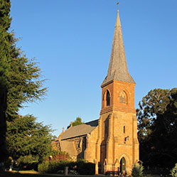
- St Johns Church
- Government House Lookout
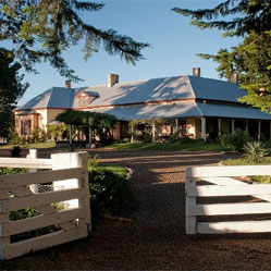
- Lanyon
- Calthorpes' House
- Old Parliament House
Video
The land
You'll traverse an environment descriptively named the 'Limestone Plains' by those British explorers. The plains were made up of sedimentary rocks (sandstone, limestone, siltstone and shale) laid down 460 million years ago, when the region was under the sea.
The newcomers were delighted to discover the Molonglo River bisecting the plains and the large Murrumbidgee River on the western margin. The Murrumbidgee arises in Kosciuszko National Park and flows almost due north for about 66km through the ACT before turning west towards eventual confluence with the Murray River about 1,500km downstream. This land had been occupied by Aboriginal people for more than 20,000 years (see Track 1). The Murrumbidgee River was an important place used by the Ngunnawal, Wiradjuri and Ngarigu people, and campsite remains can still be seen clustered around easy crossing points.
There were fine views of the distant Australian Alps to the south and west, local hills, and an open eucalypt woodland with a grassy understory. In low-lying areas, trees were sparse due to the heavy frosts that lay there on winter nights. The land later occupied by Canberra was covered by grasses (including Poa tussocks, kangaroo grass (Themeda triandra), wallaby grasses (Austrodanthonia spp.) and weeping grass (Microlaena stipoides) and scattered large trees, mainly yellow box (Eucalyptus melliodora), red gum (E. blakelyi) and apple box (E. bridgesiana).
The limits of location
This magnificent landscape was a drawcard just as it would be for Canberra's later planners, but the main attractions were grass and water for the colony's expanding flocks. Aborigines' description of a large inland river (the Murrumbidgee) caught the interest of men travelling far from Sydney seeking pasture for their flocks. In 1820 Dr Charles Throsby, who owned the first homestead on the southern tableland, sent his nephew Charles Throsby Smith, his convict overseer Joseph Wild, and James Vaughan in search of the river.
They found the Limestone Plains and the Molonglo River, but not the Murrumbidgee. Smith argued with his uncle, refusing to believe the river existed, but in 1821 Throsby himself located the Murrumbidgee. He was 'happy to report that the country is perfectly sound, well-watered with extensive meadows of rich land on either side of the rivers, contains very fine limestone, slate, sandstone and granite fit for building, with sufficient timber for every useful purpose'. This discovery of fresh grazing lands and good rivers was important news, reported in The Times in London.
The new settlers soon brought these high pasturelands into a global economy of grazing sheep for wool. The Limestone Plains lay close to the 'limits of location', set by Governor Darling for NSW in 1829. The Murrumbidgee River formed a western boundary of the official limits. No-one was meant to settle beyond them, although squatters soon moved into the mountains across the river. NSW was divided into 19 counties within the boundaries. The Limestone Plains in the County of Murray had a European population of just 171. Sheep outnumbered people until well into the twentieth century.
The best land was soon concentrated in the hands of a few families, who added to their holdings by purchase and marriage. This heritage can still be seen in Canberra. The city straddles four great pastoral estates established in the colonial period along the Molonglo River: Springbank, Canberry (Acton), Duntroon and Yarralumla.
The earliest formal landholders were men granted land by the NSW Governor. Joshua John Moore, who was given a land grant in 1823, established 'Canberry' as the first officially settled land on the Molonglo, and was the first to run stock on the Limestone Plains. 'Canberry' was derived from the Aboriginal word Kamberra (a meeting).
The next pastoral settlement on the Limestone Plains was established in 1825 by a Scottish overseer James Ainslie, who was employed by Robert Campbell. This was the beginning of Duntroon Estate, the region's main pastoral station, and a family dynasty that came to control several important Limestone Plains properties. Campbell built the first stone homestead on the Limestone Plains, establishing a sheep station called Duntroon. Duntroon House is one of Australia's oldest homesteads, built in 1833 when Yarralumla and Lanyon were also established. You'll see all three homesteads on Track 2.
Pastoral estates, farms and villages
Joshua Moore and Robert Campbell were absentee owners but many settlers arrived during the 1830s, as well as squatters and bushrangers, who quickly moved beyond the 'limits of location'. Mount Tennant was named after an Irish convict, John Tennant, who became a bushranger and used the mountain as a hideout before his capture in 1828. The first resident landholders on the plains were John and Helen McPherson around 1830. Their property, 'Springbank', was so close to the Molonglo River it is now Springbank Island on Lake Burley Griffin.
Big landowners and small farmers arrived in increasing numbers. They included the assigned convicts and free immigrants who worked for landholders as servants, shepherds, as well as farmers. To foster a settled community, the Campbells introduced a Scottish system of establishing their workers as tenant farmers, and Terence Murray of Yarralumla did the same. Small farmhouses were built for them in the valley of the Molonglo, and Blundell’s Cottage will be seen on this tour.
Farmers who took up later land selections beyond the Molonglo valley were served by the new villages of Tharwa and Hall. The district's nearest town was Queanbeyan (still in NSW). Tharwa was proclaimed in 1861-2, making it the oldest town in the ACT. 'Closer settlement' was encouraged by the Government through Robertson's Land Acts in 1861 which allowed selectors to purchase government land without auction in lots of moderate size. 'Free selectors' were required to live on their properties, and set up farms in the Ginninderra district and the Majura Valley. The village of Hall was established for them in 1881.
Most of the land in the Limestone Plains – and especially in the Molonglo valley – was held by the early grantees, and many farmers were their tenants. The leading pastoral families remained the Campbells at Duntroon and Yarralumla, the Cunninghams at Tuggeranong and Lanyon, and the De Salis family at Cuppacumbalong. Their impressive homesteads still stand but few of the free selectors' simple timber slab cottages have survived.
It's hard to imagine the isolation of a place that's now less than three hours drive from Sydney. Richard Shumack, hired by the Campbells on arrival from Ireland in 1856, took three weeks to travel with his family by horse and cart from Sydney, slowed by an accident and torrential rains. Both floods and fires were a local menace. Reverand George Gregory, the first Rector of St John's Church, drowned crossing the flooded Molonglo River in 1850. Flooding was one of many continuities between life on the Limestone Plains and in the federal capital because city dwellers faced the same risk as Canberra was built on the floodplain of the Molonglo (see Track 3).
People's lives changed when communications improved, especially after the railway reached Yass in 1876, although the roads remained rough. Post offices were established from 1859. New technologies also changed farming life. Hand-tools were replaced by machinery and boundary-riders replaced shepherds when paddocks were fenced. Wool remained the main product. Farmers did plant crops, such as the potatoes grown by Irish selectors. The wildly varying climate exposed grain crops to everything from drought to snow, and a disease called rust ravaged wheat. During the 1880s Edward Farrer developed a rust–resistant strain on his property 'Lambrigg' near Tharwa, providing a boon to wheat–growers throughout Australia.
Local people welcomed the decision in 1908 to build the new federal capital, but it spelled the end of freehold tenure and the pattern of rural settlement on the Limestone Plains. A much-quoted comic description of Canberra describes 'a good sheep station ruined'.
Duntroon Station was selected as the site of the Royal Military College to train officers for the new nation's military forces. When the Royal Military College, Duntroon, opened in 1911, Duntroon House became the RMC Officers' Mess. Today you can view Canberra's oldest residence from outside or visit on guided tours and open days. On this tour you will also see other buildings erected for the Campbell family: the Anglican Church of St John the Baptist, St John's Schoolhouse, Duntroon Dairy, Mugga Mugga, and Yarralumla House.
Long-established pastoral families left as the Commonwealth resumed the land, but some moved to nearby properties, including some of the Campbell family (Woden) and the Cunninghams (Lanyon). Many small farmers and labourers, such as the Curley family, combined rural work with the task of building and providing services to Canberra.
The pattern of large freehold stations and small farms persisted until 1911 when the Limestone Plains became leasehold Federal Capital Territory, the site of Australia's new capital. The city's name 'Canberra' reinstated the old Aboriginal and pastoral name. A land at the 'limits of location' had become a 'meeting place' for all Australians.
Map
View the Heritage map at ACTmapi and click on the letters marking a site to find a pop up box with some tantalising teasers.