
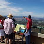
Mt Ainslie Lookout
How to get there
From the Canberra and Region Visitors Centre return northwards on Commonwealth Avenue. Take the second exit onto Parkes Way east and after 1.5 km turn left onto Anzac Parade. At the end is the Australian War Memorial. Turn right at the end then left onto Mt Ainslie Drive.
Why is this interesting?
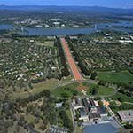
Unlike Australia's state capitals, beauty was an important factor in selecting the site of the federal capital. Surveyor Charles Scrivener chose a setting for 'a beautiful city ... worthy of the object, not only for the present but for all time.' His idea that the Molonglo River could be transformed into an ornamental lake was expressed in the Griffin Plan, and ultimately realised with construction of the dam that bears Scrivener's name. Canberra was planned as a city in the landscape. The vision reflected nationalistic ideals of the young Commonwealth and early 20th century enthusiasm for town planning.
In 1912, an international design competition for the capital was won by an American architect, Walter Burley Griffin. His plan was illustrated by his architect wife and partner, Marion Mahony Griffin. To honour the work of his wife, the viewing platform was officially named the Marion Mahony Griffin View in 2013. Their plan skilfully fitted the geometry of the city's plan to landscape features of the Limestone Plains and surrounding locality. Griffin's almost symmetrical geometric plan can be appreciated from this lookout. Your view will also take in greater Canberra: the 1920s garden suburbs, neighbourhoods and new towns constructed from the 1960s and the urban forest created by generations of tree planting.